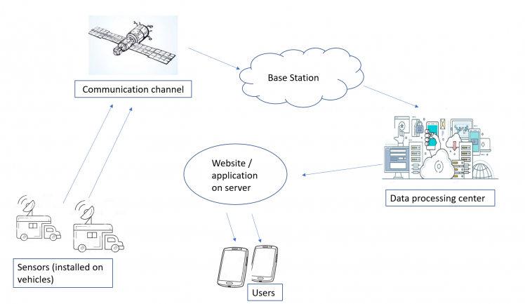
采用蓝牙Mesh的污染参数监测系统

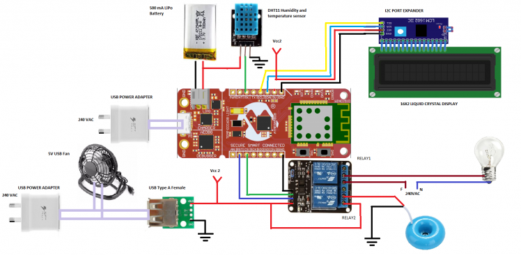
项目中使用的工具物品 硬件 Arduino Uno - R3 LCD液晶屏套件16x2字符显示 Analog 气体传感器(MQ2) 40针公插头 10 个 USB A/Micro 线束 - 2m 10...

自动驾驶竞赛车

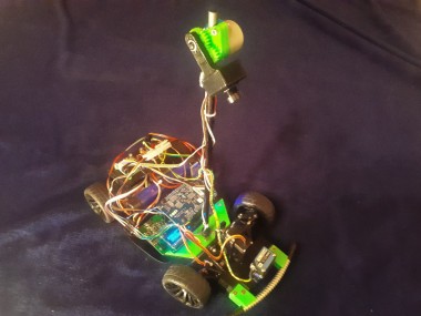
项目简介 自动驾驶汽车开始统治世界。所以让我们试着做我们自己的赛车!

物联网孵化器

项目简介 基于云决策的工业物联网终端

家庭花园工具

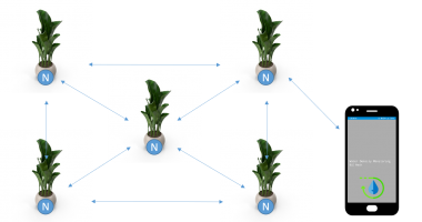
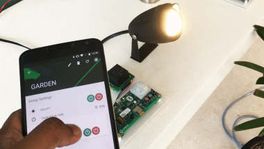
项目简介 BLE Mesh为家庭花园提供了一个简单的解决方案。

星闪联盟

星闪联盟是致力于全球化的产业联盟,目标是推动新一代无线短距通信技术SparkLink的创新和产业生态,承载智能汽车、智能家居、智能终端和智能制造等快速发展的新场景应用,满足极致性能需求。2020年9月22日,星闪联盟正式成立。

Rafavi 便携式导航信号模拟、采集、回放及测试设备

便携式导航信号采集及测试设备    可以完成30MHz~3.6GHz模拟信号的采集和存储回放,可以模拟仿真BDS、GPS、GLONASS和GALILEO多频点干扰信号和欺诈信号,主要用于GNSS 设备与应用测试、汽车自动驾驶测试、导航干扰测试、导航欺诈测试等领域。

便携式导航信号采集及测试设备

便携式导航信号采集及测试设备    可以完成30MHz~3.6GHz模拟信号的采集和存储回放,可以模拟仿真BDS、GPS、GLONASS和GALILEO多频点干扰信号和欺诈信号,主要用于GNSS 设备与应用测试、汽车自动驾驶测试、导航干扰测试、导航欺诈测试等领域。

Matlab Bluetooth Toolbox 仿真、分析和测试蓝牙通信系统

MathWorks Bluetooth® Toolbox 提供基于标准的工具来设计、仿真和验证蓝牙通信系统。它支持测试波形生成、黄金参考验证和蓝牙网络建模。 借助该工具箱,您可以配置、仿真和分析端到端蓝牙通信链路。您可以创建和重用测试平台以验证您的设计、原型和实现是否符合蓝牙标准,包括低功耗蓝牙 (LE) 和蓝牙经典标准。您还可以通过对蓝牙协议栈的多个层进行建模来评估共存、干扰、定位和 LE 音频方案。

科技新闻

国产芯片

UWB+GNSS Indoor and outdoor integrated positioning module

CM52 series products are UWB+GNSS indoor and outdoor integrated positioning module solutions...

低功耗智能离线语音交互MCU

Load More Made in China

商界市场

工作机会

便携式导航信号采集及测试设备

便携式导航信号采集及测试设备    可以完成30MHz~3.6GHz模拟信号的采集和存储回放,可以模拟仿真BDS、GPS、GLONASS和GALILEO多频点干扰信号和欺诈信号,主要用于GNSS 设备与应用测试、汽车自动驾驶测试、导航干扰测试、导航欺诈测试等领域。

专业收音降噪直播麦克风

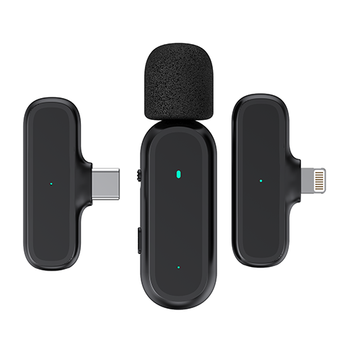
专业收音降噪直播麦克风 (抖音/直播/短视频/录音专用)
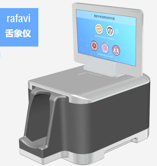
rafavi AI 智能舌相仪

集成AI人工智能,一分钟快速辨体质。

rafavi蓝牙耳机精灵系列4

.钢琴烤漆工艺  Led智能数显 .超长待机  无电量焦虑 .久戴不痛  狂甩不掉 .超强信号  高清通话

下载
Software Design and Research of PLUS Tracking and Locating System Based on UWB Technology
序号
89
software-design-and-research-of-plus-tracking-and-locating-system-based-on-uwb-technology
Ultra Wide Band (UWB) technology interests many scholars in the world, because it is a totally new communication technology which is different with the traditional ones.There is great value of UWB technology in communication, radar and locating domain.Comparing with traditional wireless communication technology such as Bluetooth,IEEE802.11, UWB is preferred in indoor locating because of its high transmission rate,high system capacity, low power consumption, good anti-multipath performance, goodpenetrability and high locating accuracy. The locating for moving objects based on UWB and wireless sensor network is a popular research topic recently. Currently, manycountries are focusing on the research and development of UWB locating technology and the relative products to monopoly the UWB market. Lots of famous universities andlaboratories are doing the research about the UWB technology, and many UWB locating systems are designed suecessfully.
Firstly, the definition, origin, development and application status of UWB technology is introduced. The PLUS target tracking and locating platform based on UWB technologyis established and debugged. This platform is the basis of the subsequent theoretical research and practical application.Secondly, the theoretical basis of UWB locating system is introduced. Through comparing many dferent locating methods, the Time Difference of Arrival (TDOA) algorithm is selected as the basic theoretical algoritm of the proposed locating system.The NLOS mitigation algorithm which aims to increase the locating accuracy is introduced and investigated as well.Thirdly, the software design and implementation of PLUS locating system is investigated. In order to track and locate the moving target, the Microsoft Visual Studio 10 version is sected as the development environment and C# as the language for the subsystem of locating software.The specific function of the developed system is listed as follows:1. System configuration and data source selection. Identify the reader, the MAC address of every reader, measured data and correction data, such as the position coordinates of the reader. Set a known value to the Z coordinates of every reader,and read the tag position information in real time from log file, simulation data or IP address.2. Network communication. Read the data with TCP/IP protocol in real time and synchronise the resource with multithreading coding method to avoid the threadlocking when the tracking is ceased.3. Data processing. Obtain the TOA information data and have them displayed, and then get the real-time position information after the processing.
A Graph User Interface (GUD) is designed to display the tracking location in real time.The master control interface of PLUS locating system is developed with Windows form designer, including menu bar, toolbar, status bar, tracking area, tag bar and alarm bar.Graph the tracking ffects with GDI+ in form designer, and obtain the tag information with ADONET and Access 2003 database. The master control interface is able to locatethe tag and display the tracking efets in real time.
In conclusion, the disadvantages of the developed system and future work are analysed.
unknown.png
2
0
0
0
13.15 MB
2023-11-25
2023-11-25
0
基于UWB的PLUS跟踪定位系统软件设计与研究_薛冰.pdf
0
2a29f16f9abe6aaf82f358bf4f94b61c
65fcd2f3d66be8e7f4cbd0f3d28fcf2eb9bebd73
0
0
0
679
679
2023-11-25
0
58
24
47
UWB, TDOA, NLOS, NET
Software Design and Research of PLUS Tracking and Locating System Based on UWB Technology
0
1
0
*
17
1
0
2358

登陆

Newsletters subscription

蓝牙网微信公众号

qrcode for gh 84b6e62cdd92 258